
CALENDAR ARCHIVE / 2006
Mining Calendar 2006 – Underground Tablets in Saxon Mining
The 13th Original Saxon Mining Calendar explores signs, inscriptions and tablets in the old mines of the Erzgebirge. Its photographs show markers connected with mining law, technical information and commemorations of notable events.
This archive contains the cover, foreword sheet and twelve monthly pages with descriptions based on the original edition. The complete introduction is also available as readable text in English translation.
13th edition · 14 calendar pages · Photographs: Jens Kugler · Design: René König / Moxxo
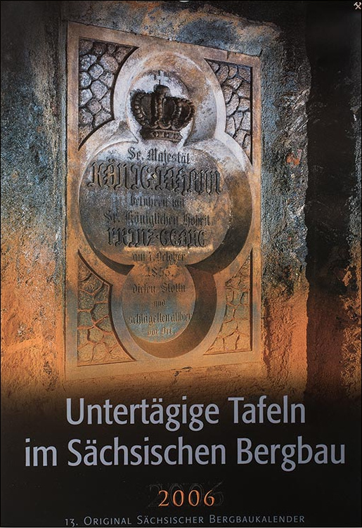
COVER · 2006
Rothschönberger Stolln – Rothschönberg
After King Friedrich August II of Saxony died in an accident in 1854, his brother Johann (1801–1873) became king. He too visited the construction works of the Rothschönberger Stolln. The large sandstone tablet on the cover commemorates this visit. Its design closely resembles the tablet commemorating his brother’s visit, shown on the December page.
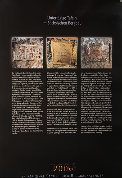
FOREWORD · 2006
Underground Tablets in Saxon Mining
The foreword sheet introduces “Underground Tablets in Saxon Mining” with three photographs of inscriptions. Below them is the complete introduction to signs, symbols, inscriptions and tablets in the old mines of the Erzgebirge. The full text follows in an English translation.
English translation of the original German introduction.
The 2006 Mining Calendar is devoted to the signs, symbols, inscriptions and tablets found relatively frequently and in a wide variety of forms in the old mines of the Erzgebirge. Miners or mining officials placed them in the workings to record important facts and pass on information. Matters that had to be documented underground for legal or technical reasons included survey results (mining-field boundaries, centres of mining fields and other reference points), the boundaries of drainage-adit districts, adit rights and changes to them, the monthly advance achieved by hewers working on piece rates, the advance of an adit or level achieved by a mine within a year, claims to ore veins discovered underground and the names of those veins. The signs, symbols, inscriptions and tablets used for these purposes were formerly generally called Stufen. More specifically, they can be distinguished as mining-boundary markers, inspection markers, adit-district tablets, markers defining sections of an adit, piecework marks, quarterly angle marks, annual advance marks, discovery tablets and vein tablets. All these types of marker were connected with the legal, technical and economic aspects of mine operation.
In addition to these markers, old mines contain inscriptions intended to commemorate important events and individuals. Construction tablets can recall the completion of a pumping installation, an important bypass adit or complex underground masonry. The breakthrough point of an adit driven from opposite ends was often marked by a breakthrough inscription or tablet, which may give the exact date of the breakthrough. Elaborately designed inscriptions and inserted tablets commemorate visits to mines by persons of high rank. Other events that left inscriptions in old mines included floods, accidents and the beginning or end of mining activity. Inscriptions and tablets of this type are called event tablets.
Markers and tablets were also installed to convey technical information without significance in mining law. At shaft stations, tablets gave the name of the shaft and the connected adit, together with the shaft depth. Vein tablets were supplemented with the distance to the next shaft and arrows showing the direction.
As early as the High and Late Middle Ages, markers in the form of small, simply designed symbols were cut into the rock. In the sixteenth century, the rapid increase in literacy brought dates, individual letters and abbreviations as well. After the end of the Thirty Years’ War and the expansion of the system of direct state control of mining, markers and inscriptions became increasingly extensive as a result of regulations and other instructions issued by the mining authorities. An unmistakable trend towards greater craftsmanship can be seen. Alongside markers and inscriptions cut into the bedrock, elaborately designed tablets appeared. Skilled craftspeople made them above ground from various materials (sandstone, gneiss, metal and wood), and they were installed underground at a prepared location. The increased need for representation and the desire to convey ever more detailed information occasionally led to very large tablets. With the reform of mining administration, the abolition of direct state control and the introduction of an inspection-based system from the middle of the nineteenth century, less effort was spent on markers and inscriptions. To save costs, painted wooden tablets, and more rarely carved ones, increasingly came into use.
Investigating signs, symbols, inscriptions and tablets through underground documentation and the study of historical sources is a fascinating field of mining-history research.
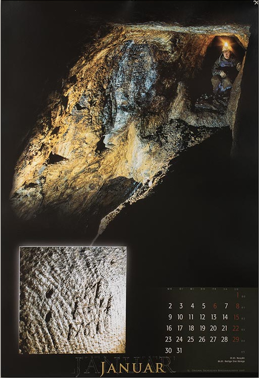
JANUARY · 2006
Junge Drei Brüder Stolln / Neuglücker Stolln – Lauta
The extensive mining at Kiesholz near Lauta remains visible today in an impressive landscape of spoil heaps and mining depressions. Inserted tablets and inscriptions cut into the rock survive in the historic underground workings. Several carved Vier-Pfennig-Stufen occur within a very small area in the Junge Drei Brüder Stolln. The Neuglücker Stolln, one of the deepest adits reaching the workings, also contains markers from the eighteenth century.

FEBRUARY · 2006
Tiefer Gideon Stolln – Großolbersdorf
Various adits were driven from different valleys to drain the mines at Kiesholz and Lauta. One deep adit was the Tiefer Gideon Stolln, begun in the middle of the sixteenth century. Although work resumed during later mining periods, it never broke through to the major mines at Kiesholz. The date cut into the rock refers to the early phase of the adit’s operation.

MARCH · 2006
Thelersberger Stolln – Brand-Erbisdorf
Between the sixteenth and nineteenth centuries, the Thelersberger Stolln, more than 50 kilometres long, became the most important drainage adit in the southern Freiberg district. It contains tablets and inscriptions from all periods of operation. The photograph shows a direction tablet, still in its original position, pointing to two ore veins and the Kälbertanz shaft. An original wooden shaft tablet also survived at a station in the stepped shaft.

APRIL · 2006
Rothschönberger Stolln – Halsbrücke
A fatal accident occurred in the Rothschönberger Stolln, within the Beihilfe Erbstolln mining field, on 17 February 1883. Hewers J. K. Richter and H. M. Johne caused nitroglycerin to explode while drilling a hole with a drilling machine. It was suspected that the explosive had entered fissures in the rock when drill holes were charged during the preceding shift. The small tablet was cut into the rock in memory of the two miners. The larger tablet stands near the seventh access shaft at Halsbrücke, at the beginning of a branch towards Beihilfe Erbstolln. It marks the end of the section financed by the Saxon state for that mine. Further advance into the Beihilfe mining district was the mine’s responsibility.

MAY · 2006
St. Briccius – Königswalde
St. Briccius lies on the eastern slope of the Pöhlberg. Mining began in the second half of the fifteenth century, making it one of the oldest mines in the Annaberg district. Its principal target was silver-bearing copper ore. The photograph shows a winze coated with secondary minerals. Numerous Schneeberg-type piecework marks from the fifteenth and sixteenth centuries occur throughout the extensive workings.

JUNE · 2006
Tiefer Bünau Stolln – Zinnwald
Mining for tin, tungsten and other ores at Zinnwald was generally overshadowed by the better-known Altenberg mines, principally because its output was smaller. Zinnwald’s main period of prosperity was between 1550 and 1600. Extensive excavations in the Zinnwald ore beds and large stopes survive from this intensive mining. Various adits drained the district. A central role was played by the Tiefer Bünau Stolln, started in the middle of the sixteenth century. The annual advance mark cut into the rock refers to the eighteenth-century operating period.

JULY · 2006
Alter / Tiefer Fürstenstolln – Conradsdorf
The portals of the Hauptstollnumbruch and the Tiefer Fürstenstolln lie about 200 metres east of the road bridge between Tuttendorf and Conradsdorf. Until the Rothschönberger Stolln reached the workings, the Fürstenstolln was the Freiberg district’s principal drainage adit. Its lower section lost that function when the Hauptstollnumbruch was completed in 1850. The portal remained important to Freiberg’s mining tradition. The so-called Nullpunktgrotte was established here in 1851. A large sandstone tablet behind the grille marked the elevation datum used for surveys and sectional drawings in the historic Freiberg silver mines.

AUGUST · 2006
Perl Schacht – Niederpöbel
Tin and copper mining was carried on extensively for centuries around Niederpöbel and Sadisdorf. In 1854, six mines united as the Pöbler Bergbauverein. They intended to explore the veins at greater depth through a main shaft sunk from 1856. A chamber was excavated for a waterwheel used to drive the pumps, and a wheel 9.2 metres in diameter was installed. The tablet cut into the rock records the completion of the pumping installation.

SEPTEMBER · 2006
St. Christoph – Breitenbrunn
Numerous mines around Schwarzenberg worked skarn ore deposits, supporting the local iron and tinplate industries. St. Christoph is documented from the middle of the sixteenth century. Its ores included tin and iron, pyrite, arsenopyrite and chalcopyrite, as well as the black variety of sphalerite named after the mine, christophite. The St. Christoph Stolln opens the worked skarn deposit. It contains the annual advance mark “Quartal Trin. 1725”. The ore chute dates from the mine’s final operating period in the twentieth century.

OCTOBER · 2006
Thelersberger Stolln – Brand-Erbisdorf
The skilfully carved vein tablet, giving a distance in Lachter, stands in the Thelersberger Stolln at the intersection of the Wegweiser Stehender and Dornensträucher Spat veins. It was probably made in the first half of the nineteenth century. The distance to the intersection of the Wegweiser Stehender and Einhorn-Spat veins is 193 Lr. (382 metres).

NOVEMBER · 2006
Tiefer Hilfe Gottes Stolln – Obergruna
The Tiefer Hilfe Gottes Stolln has its portal in the Mulde valley near Obergruna. It was driven between 1789 and 1812 and drained, among others, Gesegnete Bergmannshoffnung, the northernmost major mine of the central Freiberg district in the nineteenth century. A large sandstone boundary tablet stands between the mining fields of the adit and Gesegnete Bergmannshoffnung. In 1825, the Royal Chief Mining Office and the estates resolved to extend the adit, financed by the estates, to mines farther south along the Mulde. The point defining the new section, marked by an extensively inscribed sandstone tablet, was near the Steyer shaft of Gesegnete Bergmannshoffnung. The new section was named Treue Sachsen Stolln.

DECEMBER · 2006
Rothschönberger Stolln – Rothschönberg
King Friedrich August II of Saxony (1797–1854) visited the Rothschönberger Stolln on 25 August 1852, travelling from the portal to the working face. Construction had begun in 1844. A sand collapse in 1851 northeast of the first access shaft meant that the connection between the portal and that shaft had not yet been completed. An elaborately designed sandstone tablet, approximately 1.0 by 1.3 metres, commemorates the royal visit.


