
CALENDAR ARCHIVE / 2003
Mining Calendar 2003 – From the Heights to the Depths
The tenth Original Saxon Mining Calendar explores Saxon mining history under the theme “From the Heights to the Depths”. Aerial views and a processed satellite image reveal mining landscapes and installations, while historical photographs show earlier working environments, equipment and structures.
The Original Saxon Mining Calendar has been designed as a wall calendar since 1994. This archive presents the cover and all twelve monthly pages of the 2003 edition. The captions identify the locations and subjects using the accompanying calendar text and its image credits.
10th edition · 13 calendar pages · Design: FORMART Werbeagentur
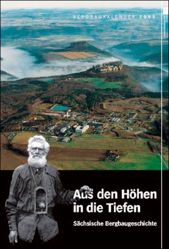
Cover · 2003
Saxon Switzerland and Königstein Fortress
The cover introduces the theme “From the Heights to the Depths – Saxon Mining History” with a view across Saxon Switzerland towards Königstein Fortress. Below the landscape photograph is a historical image of a miner carrying a lamp. This combination of a broad landscape view and the world of mining also characterises the monthly pages, which pair views from above with historical images.
Source: Luftbildservice Büschel/Wismut GmbH; Bergbaumuseum Huthaus Einigkeit, Brand-Erbisdorf. The imprint also credits Dr. W. Runge for the cover image.

January · 2003
Zug near Freiberg – landscape and vein map
The January page shows the mining landscape of Zug near Freiberg. A georeferenced vein map by Weinhold, dated 1868, is superimposed on a processed satellite image. Settlements, fields and mapped ore veins can therefore be viewed together. A historical photograph of mining work supplements this overview in the lower panel.
Source: Vein map: Weinhold, 1868. Processed satellite image: G.E.O.S Ingenieurgesellschaft GmbH, Tuttendorf.
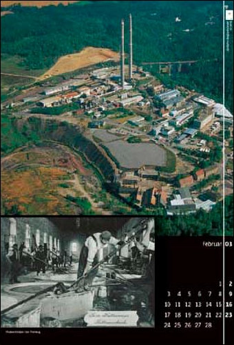
February · 2003
Muldenhütten – smelting works and furnace work
The aerial photograph of Muldenhütten near Freiberg shows an extensive industrial complex with tall chimneys, workshops and operational areas beside woodland. Below it, a smelter is seen working at the Pattinson furnaces. The accompanying text credits Reymann and dates the image to around 1910. The page brings together the layout of the smelting site and a historical view of work inside it.
Source: Reymann, c. 1910; Postkartensammlung Matthias Pomsel Freiberg.
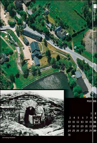
March · 2003
Schneeberg-Neustädtel – stamp mill and adit
The March page turns to the Siebenschlehner stamp mill in Schneeberg-Neustädtel. The aerial view shows its buildings beside a pond, roads and green spaces. The historical image below depicts the masonry portal of the Gesellschafter Stolln; the notes date it to the early twentieth century. The two subjects document different surviving features of mining in the same locality.
Source: Early twentieth century; Fotothek; Museum für bergmännische Volkskunst Schneeberg.

April · 2003
Kleinvoigtsberg – Alte Hoffnung Gottes
The aerial photograph shows Kleinvoigtsberg amid fields, gardens and wooded areas. According to the accompanying text, the historical image in the lower part of the April page relates to the Alte Hoffnung Gottes Erbstolln mine. It shows a worker with a mine wagon on elevated tracks. The image is credited to Reymann and dated to around 1900, connecting the landscape with the locality’s mining history.
Source: Reymann, c. 1900; Sammlung Ortsverein Kleinvoigtsberg.

May · 2003
Lauta – spoil heaps and horse-powered winding
The May page shows the landscape around Lauta near Marienberg, including settlements, fields and a line of mining spoil heaps. The accompanying text identifies this line as “Bauer Mgg.”. The historical photograph below shows the horse-powered winding installation at the Rudolph Schacht around 1877. The page connects traces of mining visible in the landscape with an earlier installation for shaft hoisting.
Source: C. 1877; Bibliothek der Bergakademie Freiberg; WA Altbestand Nachlaß Dr. Sommer.
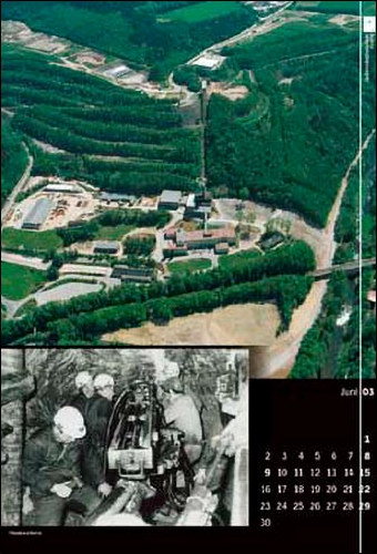
June · 2003
Niederschlema – Shaft 371
The aerial photograph shows SDAG Wismut’s Shaft 371 complex in Niederschlema. Buildings, the headframe and terraced areas sit within a largely wooded landscape. The notes describe the site as a Wismut heritage centre. In the historical image below, several miners stand beside underground machinery. The pairing connects the surface installations with a glimpse of the working environment below ground.
Source: Archiv Traditionsstätte des Uranbergbaus Schlema.
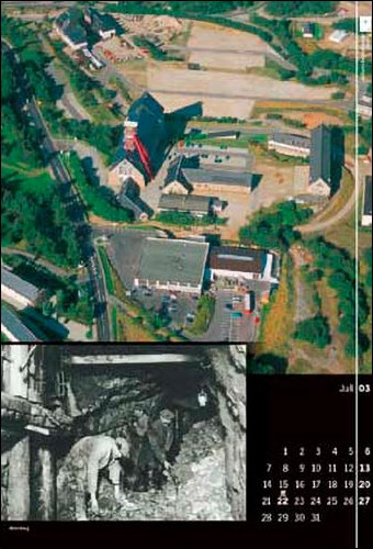
July · 2003
Altenberg – Arno-Lippmann-Schacht
The July page presents an aerial view of the Arno-Lippmann-Schacht in Altenberg. Its prominent winding tower stands among operational buildings, paths and open areas. The notes identify the historical underground photograph as the fourth level of the Römer Schacht, crediting Butze and the year 1920. The surface installation and earlier working scene bring together two views of mining in Altenberg.
Source: Butze, 1920; Bergbaumuseum Altenberg.
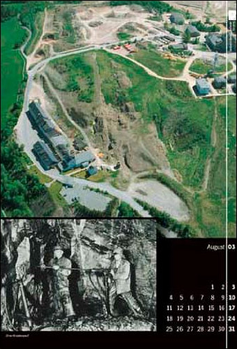
August · 2003
Ehrenfriedersdorf – Sauberger Richtschacht
The aerial photograph shows the Sauberger Richtschacht area in Ehrenfriedersdorf, with operational buildings, access routes and extensively altered terrain. The historical image below takes the viewer underground to miners working at the rock face. The accompanying text identifies the scene as shrinkage stoping and dates it to around 1952. The credit names the former company archive of VEB Zinnerz Ehrenfriedersdorf.
Source: C. 1952; former company archive of VEB Zinnerz Ehrenfriedersdorf.
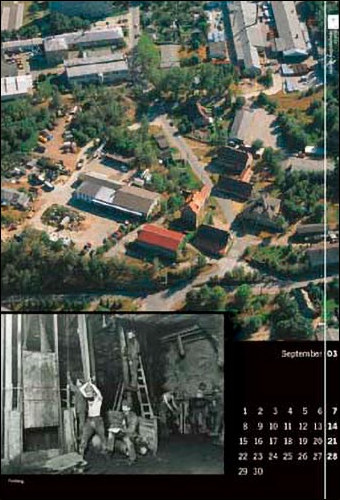
September · 2003
Freiberg – the Abraham-Schacht
The September page shows the Abraham-Schacht complex of the Himmelfahrt Fundgrube in Freiberg. The aerial photograph reveals the arrangement of buildings and operational areas within the town. Below it is a historical underground photograph from the shaft’s twelfth working level. The notes name Heinrich Börner as the photographer and give the year 1892. Timber structures, ladders and people characterise this earlier view.
Source: Heinrich Börner, 1892; Bergbaumuseum Huthaus Einigkeit, Brand-Erbisdorf.

October · 2003
Geyer – the Binge in the landscape
The October page juxtaposes two views of the Binge in Geyer. From the air, the depression appears among trees, paths and neighbouring fields. The historical photograph in the lower panel shows its rugged rock walls from a closer viewpoint. It is credited to Paul Schulz and dated 1927. The two photographs present different perspectives on the same feature of the mining landscape.
Source: Paul Schulz, 1927; Bergsicherung Dresden/Vermögensgesellschaft.
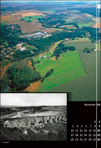
November · 2003
Halsbrücke – landscape along the Halsbrücker Spat
The November page shows the mining landscape along the Halsbrücker Spat vein. Fields, strips of woodland and buildings alternate in the aerial photograph. The historical image below depicts a long masonry structure with arches in an open landscape. The notes name Heinrich Börner and the year 1893. Both views draw attention to the spatial relationships of mining around Halsbrücke.
Source: Heinrich Börner, 1893; Institut für Wissenschafts- und Technikgeschichte an der TU Bergakademie Freiberg.

December · 2003
Pockau-Lengefeld – lime works and loading
The December page turns to the Pockau-Lengefeld lime works. The aerial view shows buildings beside a road and lower ground enclosed by rock and trees. Below it is a photograph of an operator working with an overshot loader. The page connects the lime works’ buildings with a view of its loading equipment.
Source: ZVB Sächsisches Industriemuseen Museum Kalkwerk.


